Fish Dynamics
The Spatial Analysis component of EASy includes a tuna fish movement model that uses fish catch data to predict the abundance and distribution of commercial tuna species in the Eastern Pacific.
This model statistically correlates fish catch data with water conditions (e.g. temperature, oxygen, chlorophyll, etc.) at the time and spatial location where the fish were caught.
Preferred water conditions are then extrapolated over a large portion of the Pacific Ocean to predict the fish distribution. The model then simulates fish movement within the area of interest, accounting for ocean currents, fish schooling, and the dynamically changing of ocean physical conditions. It also accounts for recruitment and schooling of both juvenal and adult fish.
One of the major improvement to the Spatial Analysis fish model by the TunaScape project is the availability of tuna fish prey, specifically zooplankton. The model now incorporates the temporal and spatial distribution of zooplankton by importing modeled images of zooplankton distribution from the ECCO-Darwin model. The vertical distribution of the zooplankton is then determined by modeling zooplankton light, temperature, oxygen, and vertical migration speed.
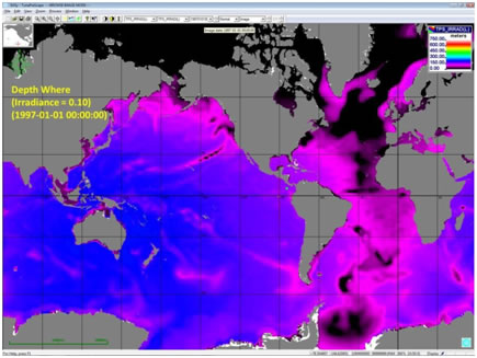
As the principal prey of tuna and other larger fish, zooplankton attempt to avoid predators during the daytime by descending to depths of low solar irradiance. The depth dimension not only makes them less visible but it also allows them to reduce their spatial density. For example, larger zooplankton may descend to a deeper depth than smaller zooplankton thereby reducing their biomass spatial density. At night they ascend to the surface where they warm up, re-oxygenate, and feed on phytoplankton and other small prey.
Zooplankton vertical migration is modeled within the TunaPreScape component of the TunaScape model. This module uses irradiance, oxygen, temperature, and the biomass density of phytoplankton, the numerical concentration of phytoplankton of a representative weight, and the physical limitations of both large and small zooplankton to determine the zooplankton depth distribution. The resulting zooplankton depth distribution is saved to a time series of global NetCDF files for later use in refining the fidelity of the TunaScape fish model. Although TunaScape model is a limited geographic region in the Eastern Pacific, the TunaPreScape zooplankton depth analysis produces global images.
Here is an example showing the depth where irradiance is sufficiently low to obscure large zooplankton from predators such as tuna.